By Kim McDarison
Survey teams have determined that three embedded tornados affected the south-central Wisconsin region Sunday, Michael Musher, a public affairs specialist/meteorologist with the National Weather Service (NWS), wrote, updating WhitewaterWise and Fort Atkinson Online by email on Tuesday.
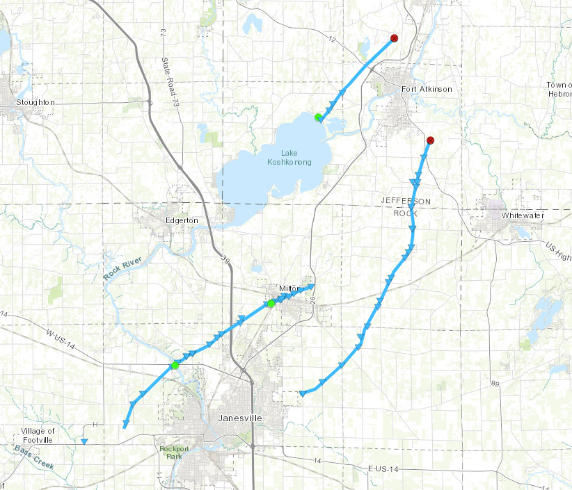
After investigating storm damage in several locations, the NWS in Milwaukee has determined that an EF-0 tornado was present in Rock County, originating in Footville and tracking for some 12.23 miles to Milton. The storm traveled, with peak winds of 80 miles per hour, and had a maximum width of 50 yards.
According to a storm summary, the NWS has noted that the storm began west of Janesville and tracked northeast toward Milton, where it went through “the high school area,” and the north central part of town.
Damage was reported as “mainly tree damage,” with a bleacher section in a baseball field lofted over a fence at the high school.
The tornado was active between 5 and 5:21 p.m.
Additionally, the NWS has reported that a tornado on Sunday in Jefferson County, also with a rating of EF-0, with winds peaking at 65 miles per hour, developed over Lake Koshkonong and tracked toward the northwest side of Fort Atkinson. The storm left a path some 5.57 miles long, with a maximum width of 30 yards.
The tornado was active between 5:27 and 5:37 p.m.
A third tornado, was identified, which traveled through Rock and Jefferson counties, starting east of Janesville in Harmony/Lima Center, and moving with peak winds of 80 miles per hour to an area in the vicinity of Highway 12, between Fort Atkinson and Whitewater, leaving a path some 15 miles long.
The EF-0-rated storm, made a path with a maximum width of 50 yards, and was active between 5:15 and 5:38 p.m.
According to a NWS summary, damage included uprooted trees and an empty grain bin was tipped, with its roof damaged.
No deaths or injuries were reported as a result of the three storms.
Additionally, the summary includes an understanding of the Enhanced Fujita (EF) scale, which is used to classify tornados, as follows:
• EF-0: the storm is considered “weak,” with wind speeds between 65 and 85 miles per hour.
• EF-1: the storm is considered “moderate,” with wind speeds between 86 and 110 miles per hour.
• EF-2: the storm is considered “significant,” with wind speeds between 111 and 135 mile per hour.
• EF-3: the storm is considered “severe,” with wind speeds between 136 and 165 miles per hour.
• EF-4: the storm is considered “extreme” with wind speeds between 166 and 200 miles per hour.
The full summary of the three storms is found here: https://www.weather.gov/mkx/Tornados2024May26.